4Th International Workshop of the ERC CoG MICOLL. Merchants' Routes 2.0. From Archives to the Web
4Th International Workshop of the ERC CoG MICOLL.Merchants' Routes 2.0. From Archives to the Web.
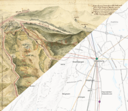
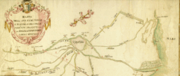
Il MobiLab ha preso parte al 4th International Workshop dell’ERC COG MICOLL, intitolato “Merchants’ Routes 2.0. From Archives to the Web“, che si è tenuto a Genova nei giorni 22 e 23 gennaio 2026.
L’evento, organizzato in collaborazione con l’Archivio di Stato di Genova e l’Università degli Studi di Padova, ha esplorato il passaggio cruciale dai documenti d’archivio alla loro valorizzazione digitale sul web. Il workshop ha rappresentato un’importante occasione di confronto internazionale tra direttori di archivi (Venezia, Lubecca, Norimberga e Genova) e ricercatori, focalizzandosi sull’uso della cartografia storica e delle tecnologie digitali per la ricostruzione delle rotte commerciali.
Il contributo si è svolto nella sessione dedicata alla digitalizzazione delle rotte commerciali. Stefania Gialdroni, Giorgio Di Nunzio e Marco Orlandi hanno presentato un intervento dedicato a “Le mappe del progetto MICOLL“.
La relazione ha illustrato come le tecnologie digitali e l’approccio scientifico alle vie del commercio permettano di trasformare i dati estratti dai documenti d’archivio in strumenti cartografici dinamici. Attraverso l’integrazione di competenze multidisciplinari, il lavoro presentato ha mostrato l’evoluzione delle mappe del progetto MICOLL e dell’atlante del progetto IUSTITIAM, sottolineando come la cartografia digitale sia oggi uno strumento essenziale per visualizzare e analizzare i flussi mercantili e la diffusione del linguaggio commerciale tra l’XI e il XVII secolo
XVII Seminario di Studi Storico-Cartografici: Dalla mappa al GIS
XVII Seminario di Studi Storico-Cartografici: Dalla mappa al GIS
Il MobiLab ha preso parte al XVII Seminario di Studi Storico-Cartografici: Dalla mappa al GIS, che si è tenuto presso il Dipartimento di Studi Umanistici dell’Università Roma Tre nei giorni 13 e 14 novembre 2025.
L’edizione di quest’anno si è focalizzata sul tema “Culture e tecniche del territorio: Esperienze, ricerche e progetti per la mitigazione dei rischi ambientali”.
Il seminario ha rappresentato un’importante occasione di dibattito sull’utilizzo della cartografia storica e delle metodologie avanzate come i GIS, per recuperare i saperi locali e supportare la corretta progettazione di modelli di ricerca per la gestione dei rischi idrogeologici e sismici.
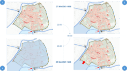
Il nostro contributo, presentato da Marco Orlandi e Mauro Varotto, è stato intitolato: “La memoria dell’acqua: l’alluvione del 1636 a Ravenna tra cronaca, cartografia storica e rischio idraulico contemporaneo”.
La relazione ha analizzato, attraverso l’utilizzo di un Historical GIS (HGIS), il rapporto diacronico tra la città di Ravenna e le sue acque. Il lavoro ha integrato fonti storiche (cronache dell’alluvione del 1636, cartografia settecentesca delle sistemazioni dei fiumi Ronco e Montone) con i dati geospaziali contemporanei. Lo studio ha evidenziato come la conoscenza del passato, supportata dalle tecnologie HGIS, sia uno strumento essenziale per la comprensione e la pianificazione del rischio idraulico attuale, soprattutto alla luce degli eventi come l’alluvione del maggio 2023.
Archivio Storico Comunale di Ravenna. Mappe, 243
https://www.cdc.classense.ra.it/s/Classense/item/26901

5th DARIAH-HR International Conference Digital Humanities & Heritage 2025
5th DARIAH-HR International Conference
Digital Humanities & Heritage 2025
MobiLab participated in the 5th DARIAH-HR International Conference Digital Humanities & Heritage, which was held in Osijek, Croatia, from October 22nd to 24th, 2025.
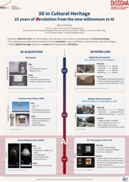
Our contribution, presented during the poster session (viewable here), was titled “3D in Cultural Heritage: 25 years of (r)evolution from the new millennium to AI”.
The research analyzed how 3D technologies consolidated their position in the methodology for documenting, analyzing, and disseminating cultural heritage between 2000 and 2025. This evolution, which profoundly transformed tools, workflows, and costs, established Digital Heritage as an autonomous and mature discipline.
The analysis focused on the two fundamental research lines of 3D: the acquisition of tangible heritage and 3D modelling for historical reconstruction.
Regarding acquisition, the poster illustrated the transition from initial systems like 3D Scanners and Structure from Motion (SfM) applications to the recent techniques of Generative AI (GenAI), such as Neural Radiance Field (NeRF). These innovations were shown to increase accessibility by enabling high-resolution acquisition straight from video with minimal post-processing.
For historical modelling, the research mapped the fragmentation of the methodological workflow: moving from a single-software environment to the combined use of various specialized applications.
Finally, the study highlighted the impact of AI, which, by automating the creation of complete 3D models from image or text input, is opening new frontiers for the realization of historical virtual scenes and digital characters.

Mapping the perception of the Polytheistic heritage in the city fabric of Ostrogothic/Byzantine Rome (500-750 ca.)
Mapping the perception of the Polytheistic heritage in the city fabric of Ostrogothic/Byzantine Rome
(500-750 ca.)
Postdoctoral project supervised by Prof. Maria Cristina La Rocca (March 2024 -August 2026)
Nicola Luciani
Starting from the last decade of the 5th century, the city of Rome was part of an Ostrogothic kingdom established with the formal consent of the Empire, that consequently maintained strong diplomatic and administrative links with the Italian peninsula. What is more, Byzantium was able to again impose direct imperial rule over the city from the mid-6th century, following Justinian’s wars in the West. From then on, for about two hundred years Rome was under the direct rule of the Emperor’s government, until the gradual waning of Imperial authority in the 8th century.
During such period, despite its peripheral position in respect to the political core of the Empire, the city of Rome was still regarded as a prime ideological centre of the Mediterranean oecumene. A crucial expression of such status within the urban fabric was represented by the Classical monumental panorama. Indeed, under Ostrogothic and Byzantine rule, Rome’s pre-Christian sacred structures were still actively employed to host
important public activities and to transmit civic symbolisms directed to the people inhabiting or visiting the metropolis.
As a central tenet of the project “PagByzRome – administration and perception of the Pagan heritage in the urban fabric of Byzantine Rome”, the city’s Polytheistic heritage is therefore employed to explore the relationship between the city-space and its inhabitants during the entire chronology of Ostrogothic and Byzantine Italy.
Accordingly, data regarding Polytheistic scared structures and sculptures are collected within a map of Early Medieval Rome, with the possibility of accessing information regarding the interested contexts. The map is structured according to a diachronic perspective, presenting layers corresponding to different main phases (Rome at the beginning of the 6th century, under Ostrogothic rule – Rome during the second half of the 6th century, after the Imperial conquest – Rome in the mid-7th century, under Eastern Imperial rule – Rome in the mid-8th century, around the end of Imperial direct control).
The mapped contexts are also presented in relation to prominent ritual routes winding through the city, including processions promoted by secular and religious authorities, such as Imperial adventus or Papal litanies.
The mapped Polytheistic religious heritage within the city fabric is indeed explored in light of its roles in the interactions among the city’s different social groups (including Church hierarchies, Gothic élites, Eastern government authorities, Latin-speaking inhabitants), each characterized by distinctive cultural roots that impacted their understanding of Rome’s Classical structures.


Mobilities, international business and global mining capitalism. The French mining engineers abroad (19-20th cent.)
Mobilities, international business and global mining capitalism. The French mining engineers abroad (19-20th cent.)
Digital project coordinated by Marco Bertilorenzi
Project overview
Research team:
- Prof. Marco Bertilorenzi
- Dr. Jean-Philippe Passaqui (Université Paris 1 Panthéon Sorbonne)
- Prof. Nadine Dubruc (Ecole des mines de Saint-Etienne)
- Dr. Marco Orlandi
Goals:

The welfare of migrants: institutions, families and belongings in Italy (sixteenth to nineteenth centuries). (WELMIG project)
The welfare of migrants: institutions, families and belongings in Italy (sixteenth to nineteenth centuries).
(WELMIG project)
Postdoctoral project supervised by Andrea Caracausi (Dec 2022 - Dec 2025)
Beatrice Zucca Micheletto
WELMIG investigates the relationship between mobility and the welfare system in early modern and modern pre-unitarian Italy, spanning from the middle of the sixteenth century to the middle of the nineteenth century. WELMIG focuses on a range of welfare institutions (charity institutions, hospitals, workhouses, welfare agencies) and exploits their historical archives across the Italian peninsula. It will collect information on the socio-economic profile of individuals and families who received assistance and/or were committed in the ordinary activities of the welfare institutions. It will adopt an intersectional approach, paying attention to gender, age, class, religion and ethnicity of recipients and of the people who revolved around these institutions. At the same time it will analyze how the hosting societies of the past organised and managed the access to local resources for newcomers and migrants, the implementation of norms and laws and the coherence (or not) between norms and practices.
WELMIG links the history of the welfare institutions to the mobility turn in social science and dialogues with a range of historiographical approaches – gender history, social history, labour history, family history. It will promote debate and exchange of ideas on the topic for academic and non-academic public with the support of the MobiLab, and with the collaboration of the University of Cambridge (Campop) and the international network WeMove (CA19112).


From Venice and Rome to Mainz: Italian Books from Humanism to Counter-Reformation in the Library of Baron Johann Christian von Boineburg
From Venice and Rome to Mainz: Italian Books from Humanism to Counter-Reformation in the Library of Baron Johann Christian von Boineburg
Postdoctoral project supervised by Paola Molino
(June 2021 - May 2022), within the PRIN project 'Books in Motion'
Gábor Gángó
The “Maecenas Germaniae,” the Baron Johann Christian von Boineburg (1622-1672) was a book collector, patron of the arts, Lord Marshal at the court of the Mainz Elector Johann Philipp von Schönborn, and not least friend and supporter of the young Gottfried Wilhelm Leibniz. Boineburg’s private library as an encyclopaedic, with an abundant number of hand-written cross-references interconnected “database” and his extended scholarly correspondence provides the source basis for the mapping of the international network of politically, denominationally, and scholarly engaged intellectuals after the Peace of Westphalia.
Gábor Gángó’s project aims at the reconstruction of Boineburg’s role in the knowledge transfer between Germany and Italy. This research would encompass details of the acquisition, circulation, and reviewing of Italian books within his network as well as the determination of the place which science and theology that were produced in Italy occupied in Boineburg’s ever-broadening system of knowledge.
Besides, the project will focus on the issue of confessionality in Boineburg, which crystallised in a special way in his conversion. Boineburg, who received a Lutheran education in Jena and Helmstedt, was converted at the Imperial Diet of Regensburg in 1653. In the literature, his better career prospects at the court of the Mainz Elector are given as possible reasons. Here Gábor Gángó wants to overcome the previous state of research and also reveal the intellectual motives for the conversion. To this end, he will also examine the collective thought processes in Boineburg’s correspondence with other scholars. This collective communication and thought process has a lot to do with Italy and cannot be understood without the Italian context. As it will be shown on the collected source materials, impulses of the Counter-Reformation in the 17th century in general and also particularly in Boineburg’s case came from Rome.
As a result, one would be in a better position to understand, through the case study of an important German Catholic convert, the mid-17th-century reconciliation attempts between the authority of the Catholic Church and the aspirations of modern science and philosophy for the possession of true knowledge.


Occupational structure and labour mobility in historical perspective: Italy and the Mediterranean
Occupational structure and labour mobility in historical perspective: Italy and the Mediterranean
Digital project coordinated by Andrea Caracausi
Project overview
This research project explores the evolution of occupational structures and labour mobility from a long-term perspective. It addresses both the way people worked and were on the move in the past and specifically how their occupational choices, migrations and labour relations were affected by global dynamic forces such as warfare mobilization or structural economic changes. By focusing on Italy and the Mediterranean area from the late medieval period to the beginning of the nineteenth century, the project aims to shed new light on the continuity and changes in work, labour mobility, and geographical diffusion of economic activities. In collaboration with the Digital Laboratory for Mobility Research (MobiLab), the research will combine quantitative and qualitative analysis of empirical sources (such as census or lists of convicts and slaves) with the use of digital tools. In particular, GIS techniques will be used in order to map the mobility of people and their shifting occupations as well as to improve the understanding of mobility phenomena from an analytical point of view.
Subprojects
Occupation and Health in Padua Between the 19th and 20th Centuries
This project aims to examine the relationship between occupation, residence, and mortality in the city of Padua from the late 19th to the early 20th century. By analyzing death records preserved in the “Anagrafi” collection at the State Archive of Padua, we will study how individuals’ social and occupational status evolved over time in relation to mortality. Our goal is to shed light on the connections between causes of death, occupation, and urban stratification during this crucial period in Italian history. The research will contribute to a deeper understanding of the socio-economic dynamics in the Padua area during the transition to industrialization and will provide valuable insights into the broader debate on the relationship between professional status, urban stratification, and public health in post-unification Italy.
Work and Migration in Padua: Occupational Mobility in the Early 20th Century
This project (student: Marta Cannicci) seeks to investigate occupational mobility to and from Padua in the early 20th century. Drawing on immigration and emigration register held at the Padua State Archives, it examines the occupational profile and social stratification of migr
ants recorded by the registry office. In particular, we will use HISCO and HISCLASS to analyze the relationship between occupational titles and places of origin and destination, as well as the interplay between mobility and social class. Furthermore, a gender perspective is incorporated by considering the impact of migrants’ gender on occupational patterns and mobility trajectories. By doing so, the project aims to shed light on the occupational demands of Padua -and, more broadly, northern Italy- at the beginning of the twentieth century, along with the varying propensities of different social classes for territorial mobility.
Intergenerational mobility and occupational status in the Napoleonic Kingdom of Italy
This project seeks to investigate the patterns of intergenerational mobility and occupational status within the Napoleonic Kingdom of Italy. By examining marriage publication records, we will analyse how individuals’ social status evolved across generations. Our goal is to illuminate the mechanisms that shaped social stratification during this crucial period in European history. This research will contribute to a deeper understanding of socio-economic dynamics in central-northern Italy between the eighteenth and nineteenth centuries and provide valuable insights into the broader discussion on preindustrial social mobility.
Occupational structure and labour mobility.
A first aspect of the research project directed by Prof. Andrea Caracausi deals with the link between changing occupational structures and labour mobility in the Republic of Venice between the early sixteenth century and the beginning of the modern period (1500-1850). Discussing the consequences of political and economic changes that occurred in this period, this project aims ultimately to reconstruct the evolution of the occupational structure in the diverse territories of the Venetian Republic and to explain its determinants using an innovative statistical methodology. It also deals with social, economic and gender aspects using micro-historical approaches to reconstruct labour relations and labour mobility. In particular, it uses a verb-oriented approach in order to reconsider occupations as well as concepts as work, care and domestic labour in a gendered perspective. Thanks to Gis methods, it focuses on the movement of urban and rural people as represented by judicial sources, correspondences and diaries.
Past projects
Woman’s work in rural Italy (1500-1800). This project (post-doc fellow Dr. Mattia Viale) aims to provide a better understanding of the historical dynamics surrounding gender and work between the sixteenth and the eighteenth century in rural Italy. By incorporating diverse research methodologies and exploring various geographical contexts across the peninsula, we strive to shed light on the multifaceted nature of female participation in the pre-industrial labour force.
Mobility and forced labour. A second aspect of the research project coordinated by the postdoctoral fellow Benoît Maréchaux explores the phenomena of forced mobility of convicts and slaves transported to the galleys of Genoese galley contractors who worked for the Spanish Empire in the sixteenth and seventeenth century. The research will reconstruct the transnational flows of prisoners, analyze the agency of forced mobility and measure mortality in order to discuss the impact of coerced labor and migrations in the past and the way prisoners worked, moved and died in the early modern Mediterranean. This research is part of the project “Forced mobility before the sovereign state. Convict flows, composite polities and the business of galley warfare in the Mediterranean (1528-1715)” carried out at the DiSSGeA within the framework of the Mobility and Humanities project.
(1/2020-3/2021).
Research team:
- Prof. Andrea Caracausi (occupational structure and general coordinator)
- Dr. Giulio Ongaro (occupational structure)
- Dr. Mattia Viale (social mobility)
- Dr. Marco Orlandi (Gis and data visualization)
Past members:
- Dr. Benoît Maréchaux (forced mobility, convict labor and slaves)
Interns (Update 6 March 2025):
- Marta Cannicci
- Nicola Giannini
- Claudio Cacciatori
- Giacomo Addis
- Anna Maria Albertini
- Giovanna Cozzi
- Enrico Comini
- Gianluca Dalboni
- Marco De Nardi
- Samuele Fagherazzi
- Alma Fanigliulo
- Giovanni Favretto
- Alex Franz
- Simone Tommasi
- Alberto Peloso
- Giorgia Ragana
- Dana Belen Zuna
- Gianluca Dalboni
- Francesca Scipilliti
International Partners
– The Cambridge Group for the History of Population & Social Structure

Marriage and Mobility in Early Modern Venice
Marriage and Mobility in Early Modern Venice (late 16th-18th Centuries) – Processetti
Postdoctoral project supervised by Jean-François Chauvard (Université Paris 1 Panthéon-Sorbonne) and Walter Panciera (Sept 2020-Aug 2022)
Teresa Bernardi
The research project explores the role played by social ties within processes of migrant identification during the early modern period. The historical and geographical background of this study are the cosmopolitan city of Venice and its domains during the seventeenth century. The research is primarily based on a specific archival source: the so called processetti matrimoniali. This documentation consists in pre-matrimonial enquiries aimed at attesting the marital status, or widowhood, of foreigners and other ‘mobile people’ who wanted to get married in Venice. The project’s hypothesis is that relying on gender as a lens of analysis, along with focusing deeply on women’s mobility, may challenge some historiographical assumptions about the very phenomena of mobility and identification: respectively, the presumed clear-cut between short and long-distance mobility; and the assumed replacement of orality – in terms of reputation and social networks – by written documents.
This research is part of a bigger international programme funded by the French National Research Agency (ANR) and supervised by Prof. Jean-François Chauvard. The research group’s overall objective is to explore the relation between marriage and human mobility both from a qualitative and a quantitative perspective. It does so by comparing the city of Venice, the Greek World under the Venetian dominion and other cities of the Italian peninsula. Moreover, this programme will pursue the digitalization of a vast portion of the processetti in the context of the virtual research environment Geovistory (http://geovistory.com/). In addition to the digital humanities, this project’s research interests thus span various fields of social, legal, and cultural history.
